


Lac de l'Anterne depuis Moede

gilbinrod
User
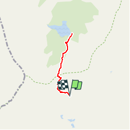

Length
4.8 km

Max alt
2250 m

Uphill gradient
425 m
Km-Effort
10.5 km

Min alt
2002 m

Downhill gradient
426 m
Boucle
Yes
Creation date :
2017-07-30 00:00:00.0
Updated on :
2017-07-30 00:00:00.0
2h03
Difficulty : Medium

FREE GPS app for hiking
 SityTrail
IGN / Geographical institutes
SityTrail Plus
The world is yours!
About
Trail Walking of 4.8 km to be discovered at Auvergne-Rhône-Alpes, Upper Savoy, Passy. This trail is proposed by gilbinrod.
Positioning
Country:
France
Region :
Auvergne-Rhône-Alpes
Department/Province :
Upper Savoy
Municipality :
Passy
Location:
Unknown
Start:(Dec)
Start:(UTM)
329613 ; 5093673 (32T) N.
Comments