


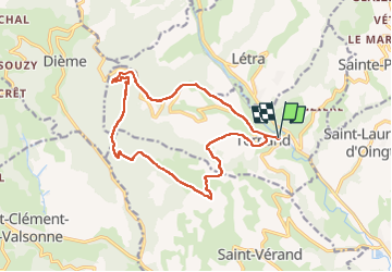
Ternand (16 km - D. 670 m)

Thomasdanielle
User


5h02
Difficulty : Difficult

FREE GPS app for hiking
 SityTrail
IGN / Geographical institutes
SityTrail Plus
The world is yours!
About
Trail Walking of 15.7 km to be discovered at Auvergne-Rhône-Alpes, Rhône, Ternand. This trail is proposed by Thomasdanielle.
Description
D/A : Parking de la gare de Ternand (Impasse de la marie).
Randonnée très agréable avec des vues magnifiques
Les dénivelés sont importants
Un pique-nique avec 2 tables se situe le long du ruisseau de Brou
Positioning
Comments