


9765247-Bretoncelles 14.11

togolo28
User
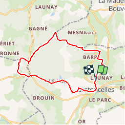

Length
14.1 km

Max alt
241 m

Uphill gradient
219 m
Km-Effort
17 km

Min alt
128 m

Downhill gradient
219 m
Boucle
Yes
Creation date :
2019-04-02 15:35:42.495
Updated on :
2019-04-02 15:36:20.106
3h42
Difficulty : Medium

FREE GPS app for hiking
 SityTrail
IGN / Geographical institutes
SityTrail Plus
The world is yours!
About
Trail Walking of 14.1 km to be discovered at Normandy, Orne, Bretoncelles. This trail is proposed by togolo28.
Positioning
Country:
France
Region :
Normandy
Department/Province :
Orne
Municipality :
Bretoncelles
Location:
Unknown
Start:(Dec)
Start:(UTM)
343650 ; 5366855 (31U) N.
Comments