


track

chasle
User
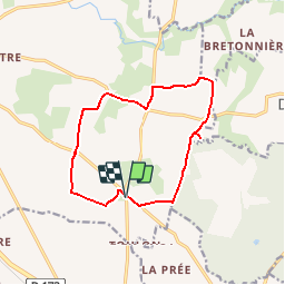

Length
11.9 km

Max alt
116 m

Uphill gradient
126 m
Km-Effort
13.6 km

Min alt
61 m

Downhill gradient
127 m
Boucle
Yes
Creation date :
2019-04-02 15:44:45.162
Updated on :
2019-04-02 16:16:29.849
2h59
Difficulty : Easy

FREE GPS app for hiking
 SityTrail
IGN / Geographical institutes
SityTrail Plus
The world is yours!
About
Trail Walking of 11.9 km to be discovered at Brittany, Ille-et-Vilaine, Retiers. This trail is proposed by chasle.
Positioning
Country:
France
Region :
Brittany
Department/Province :
Ille-et-Vilaine
Municipality :
Retiers
Location:
Unknown
Start:(Dec)
Start:(UTM)
625524 ; 5304546 (30T) N.
Comments