


cremieu

Liebeaux
User
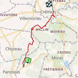

Length
9.2 km

Max alt
346 m

Uphill gradient
198 m
Km-Effort
12.1 km

Min alt
220 m

Downhill gradient
259 m
Boucle
No
Creation date :
2019-04-04 07:14:50.931
Updated on :
2019-04-04 10:31:43.065
3h16
Difficulty : Very easy

FREE GPS app for hiking
 SityTrail
IGN / Geographical institutes
SityTrail Plus
The world is yours!
About
Trail Walking of 9.2 km to be discovered at Auvergne-Rhône-Alpes, Isère, Veyssilieu. This trail is proposed by Liebeaux.
Positioning
Country:
France
Region :
Auvergne-Rhône-Alpes
Department/Province :
Isère
Municipality :
Veyssilieu
Location:
Unknown
Start:(Dec)
Start:(UTM)
672887 ; 5060941 (31T) N.
Comments