


ARIEGE: PIC DE TARBESOU

djeepee74
User
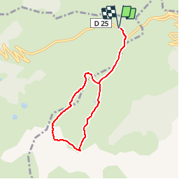

Length
6.9 km

Max alt
2351 m

Uphill gradient
413 m
Km-Effort
12.4 km

Min alt
1941 m

Downhill gradient
413 m
Boucle
Yes
Creation date :
2019-04-04 15:30:19.487
Updated on :
2019-04-10 10:04:10.867
2h30
Difficulty : Easy

FREE GPS app for hiking
 SityTrail
IGN / Geographical institutes
SityTrail Plus
The world is yours!
About
Trail Walking of 6.9 km to be discovered at Occitania, Ariège, Ascou. This trail is proposed by djeepee74.
Description
BOUCLE
Positioning
Country:
France
Region :
Occitania
Department/Province :
Ariège
Municipality :
Ascou
Location:
Unknown
Start:(Dec)
Start:(UTM)
417070 ; 4731684 (31T) N.
Comments