


Lavaré 23.07

togolo28
User
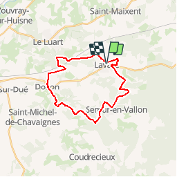

Length
23 km

Max alt
186 m

Uphill gradient
329 m
Km-Effort
27 km

Min alt
90 m

Downhill gradient
329 m
Boucle
Yes
Creation date :
2019-04-05 13:47:51.392
Updated on :
2019-04-05 13:51:45.144
5h59
Difficulty : Medium

FREE GPS app for hiking
 SityTrail
IGN / Geographical institutes
SityTrail Plus
The world is yours!
About
Trail Walking of 23 km to be discovered at Pays de la Loire, Sarthe, Lavaré. This trail is proposed by togolo28.
Positioning
Country:
France
Region :
Pays de la Loire
Department/Province :
Sarthe
Municipality :
Lavaré
Location:
Unknown
Start:(Dec)
Start:(UTM)
324504 ; 5324980 (31U) N.
Comments