


20190405taulignan

michelelfn
User
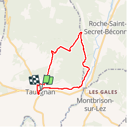

Length
12.7 km

Max alt
676 m

Uphill gradient
490 m
Km-Effort
19.2 km

Min alt
269 m

Downhill gradient
491 m
Boucle
Yes
Creation date :
2019-04-05 09:20:46.402
Updated on :
2019-04-05 16:32:16.105
6h35
Difficulty : Very easy

FREE GPS app for hiking
 SityTrail
IGN / Geographical institutes
SityTrail Plus
The world is yours!
About
Trail Walking of 12.7 km to be discovered at Auvergne-Rhône-Alpes, Drôme, Taulignan. This trail is proposed by michelelfn.
Positioning
Country:
France
Region :
Auvergne-Rhône-Alpes
Department/Province :
Drôme
Municipality :
Taulignan
Location:
Unknown
Start:(Dec)
Start:(UTM)
657721 ; 4923125 (31T) N.
Comments