


20190407roussillonocre

michelelfn
User
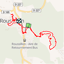

Length
3.2 km

Max alt
336 m

Uphill gradient
82 m
Km-Effort
4.4 km

Min alt
303 m

Downhill gradient
91 m
Boucle
Yes
Creation date :
2019-04-07 09:05:11.455
Updated on :
2019-04-07 11:01:08.451
1h55
Difficulty : Very easy

FREE GPS app for hiking
 SityTrail
IGN / Geographical institutes
SityTrail Plus
The world is yours!
About
Trail Walking of 3.2 km to be discovered at Provence-Alpes-Côte d'Azur, Vaucluse, Roussillon. This trail is proposed by michelelfn.
Positioning
Country:
France
Region :
Provence-Alpes-Côte d'Azur
Department/Province :
Vaucluse
Municipality :
Roussillon
Location:
Unknown
Start:(Dec)
Start:(UTM)
684256 ; 4863457 (31T) N.
Comments