20190407roussillon2

michelelfn
User
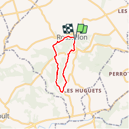

Length
8.3 km

Max alt
328 m

Uphill gradient
184 m
Km-Effort
10.8 km

Min alt
193 m

Downhill gradient
184 m
Boucle
Yes
Creation date :
2019-04-07 11:56:17.239
Updated on :
2019-04-07 15:14:51.708
3h17
Difficulty : Very easy

FREE GPS app for hiking
 SityTrail
IGN / Geographical institutes
SityTrail Plus
The world is yours!
About
Trail Walking of 8.3 km to be discovered at Provence-Alpes-Côte d'Azur, Vaucluse, Roussillon. This trail is proposed by michelelfn.
Positioning
Country:
France
Region :
Provence-Alpes-Côte d'Azur
Department/Province :
Vaucluse
Municipality :
Roussillon
Location:
Unknown
Start:(Dec)
Start:(UTM)
684270 ; 4863428 (31T) N.
Comments