


plalplan

bubu90
User
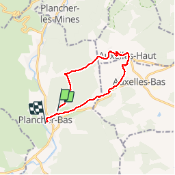

Length
10.5 km

Max alt
660 m

Uphill gradient
308 m
Km-Effort
14.6 km

Min alt
427 m

Downhill gradient
321 m
Boucle
No
Creation date :
2019-04-07 08:12:15.666
Updated on :
2019-04-08 12:55:04.048
3h21
Difficulty : Very easy

FREE GPS app for hiking
 SityTrail
IGN / Geographical institutes
SityTrail Plus
The world is yours!
About
Trail Walking of 10.5 km to be discovered at Bourgogne-Franche-Comté, Haute-Saône, Plancher-Bas. This trail is proposed by bubu90.
Positioning
Country:
France
Region :
Bourgogne-Franche-Comté
Department/Province :
Haute-Saône
Municipality :
Plancher-Bas
Location:
Unknown
Start:(Dec)
Start:(UTM)
330414 ; 5288095 (32T) N.
Comments