


Chevinay (19 km - D. 720 m)

Thomasdanielle
User
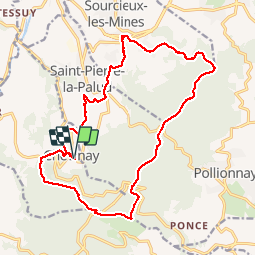

Length
19.1 km

Max alt
763 m

Uphill gradient
720 m
Km-Effort
29 km

Min alt
321 m

Downhill gradient
723 m
Boucle
Yes
Creation date :
2019-04-08 07:25:52.0
Updated on :
2019-04-08 16:32:00.61
5h55
Difficulty : Very difficult

FREE GPS app for hiking
 SityTrail
IGN / Geographical institutes
SityTrail Plus
The world is yours!
About
Trail Walking of 19.1 km to be discovered at Auvergne-Rhône-Alpes, Rhône, Chevinay. This trail is proposed by Thomasdanielle.
Description
D/A parking "Le Boutan" proche de l'église
Randonnée difficile
Positioning
Country:
France
Region :
Auvergne-Rhône-Alpes
Department/Province :
Rhône
Municipality :
Chevinay
Location:
Unknown
Start:(Dec)
Start:(UTM)
625086 ; 5069693 (31T) N.
Comments