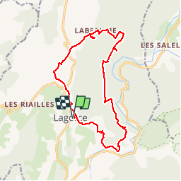
Lagorce

vaud
User

Length
17.8 km

Max alt
302 m

Uphill gradient
364 m
Km-Effort
23 km

Min alt
119 m

Downhill gradient
364 m
Boucle
Yes
Creation date :
2019-04-08 08:12:48.067
Updated on :
2019-04-08 16:33:45.886
7h03
Difficulty : Difficult

FREE GPS app for hiking
 SityTrail
IGN / Geographical institutes
SityTrail Plus
The world is yours!
About
Trail Walking of 17.8 km to be discovered at Auvergne-Rhône-Alpes, Ardèche, Lagorce. This trail is proposed by vaud.
Positioning
Country:
France
Region :
Auvergne-Rhône-Alpes
Department/Province :
Ardèche
Municipality :
Lagorce
Location:
Unknown
Start:(Dec)
Start:(UTM)
612886 ; 4922600 (31T) N.
Comments