


villeny 2019

mimilolo
User
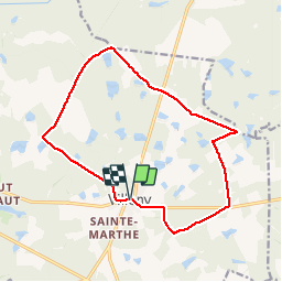

Length
14.5 km

Max alt
155 m

Uphill gradient
138 m
Km-Effort
16.3 km

Min alt
95 m

Downhill gradient
139 m
Boucle
Yes
Creation date :
2019-04-09 06:19:31.135
Updated on :
2019-04-09 16:38:32.042
3h03
Difficulty : Easy

FREE GPS app for hiking
 SityTrail
IGN / Geographical institutes
SityTrail Plus
The world is yours!
About
Trail Walking of 14.5 km to be discovered at Centre-Loire Valley, Loir-et-Cher, Villeny. This trail is proposed by mimilolo.
Description
depart parking église
Positioning
Country:
France
Region :
Centre-Loire Valley
Department/Province :
Loir-et-Cher
Municipality :
Villeny
Location:
Unknown
Start:(Dec)
Start:(UTM)
406478 ; 5275160 (31T) N.
Comments