


Morancé (12,2 km - D. 322 m)

Thomasdanielle
User
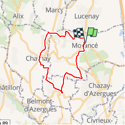

Length
12.4 km

Max alt
445 m

Uphill gradient
321 m
Km-Effort
16.7 km

Min alt
220 m

Downhill gradient
321 m
Boucle
Yes
Creation date :
2019-04-11 11:56:48.0
Updated on :
2019-04-13 00:49:36.32
3h30
Difficulty : Difficult

FREE GPS app for hiking
 SityTrail
IGN / Geographical institutes
SityTrail Plus
The world is yours!
About
Trail Walking of 12.4 km to be discovered at Auvergne-Rhône-Alpes, Rhône, Morancé. This trail is proposed by Thomasdanielle.
Description
D/A : Parking du Bourg
Positioning
Country:
France
Region :
Auvergne-Rhône-Alpes
Department/Province :
Rhône
Municipality :
Morancé
Location:
Unknown
Start:(Dec)
Start:(UTM)
631951 ; 5084171 (31T) N.
Comments