


Marche entre terre et mer (version longue)

wallander76
User

Length
39 km

Max alt
51 m

Uphill gradient
363 m
Km-Effort
43 km

Min alt
-1 m

Downhill gradient
358 m
Boucle
Yes
Creation date :
2014-12-10 00:00:00.0
Updated on :
2014-12-10 00:00:00.0
6h14
Difficulty : Very difficult

FREE GPS app for hiking
 SityTrail
IGN / Geographical institutes
SityTrail Plus
The world is yours!
About
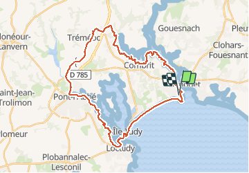
Trail Walking of 39 km to be discovered at Brittany, Finistère, Combrit. This trail is proposed by wallander76.
Description
Remontée le long de l'Odet puis de l'Anse de Combrit. Rentrée dans les terres pour rejoindre l'ancienne voie de chemin de fer direction Pont-L'Abbé. Descente de la riviére et retour par la plage.
Positioning
Country:
France
Region :
Brittany
Department/Province :
Finistère
Municipality :
Combrit
Location:
Unknown
Start:(Dec)
Start:(UTM)
416506 ; 5302263 (30T) N.
Comments