


bois de tancarville le haut

doboul
User
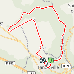

Length
9.8 km

Max alt
117 m

Uphill gradient
125 m
Km-Effort
11.5 km

Min alt
15 m

Downhill gradient
127 m
Boucle
Yes
Creation date :
2019-04-12 14:32:23.108
Updated on :
2019-04-28 08:02:44.863
2h30
Difficulty : Medium

FREE GPS app for hiking
 SityTrail
IGN / Geographical institutes
SityTrail Plus
The world is yours!
About
Trail Walking of 9.8 km to be discovered at Normandy, Seine-Maritime, Tancarville. This trail is proposed by doboul.
Positioning
Country:
France
Region :
Normandy
Department/Province :
Seine-Maritime
Municipality :
Tancarville
Location:
Unknown
Start:(Dec)
Start:(UTM)
315441 ; 5484733 (31U) N.
Comments