


20a90412gachole

michelelfn
User
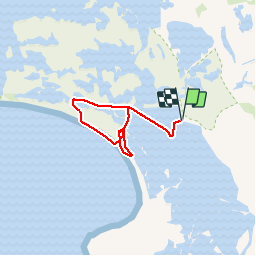

Length
22 km

Max alt
3 m

Uphill gradient
38 m
Km-Effort
22 km

Min alt
-8 m

Downhill gradient
38 m
Boucle
Yes
Creation date :
2019-04-13 09:54:23.031
Updated on :
2019-04-13 16:02:06.437
6h06
Difficulty : Very easy

FREE GPS app for hiking
 SityTrail
IGN / Geographical institutes
SityTrail Plus
The world is yours!
About
Trail Walking of 22 km to be discovered at Provence-Alpes-Côte d'Azur, Bouches-du-Rhône, Saintes-Maries-de-la-Mer. This trail is proposed by michelelfn.
Positioning
Country:
France
Region :
Provence-Alpes-Côte d'Azur
Department/Province :
Bouches-du-Rhône
Municipality :
Saintes-Maries-de-la-Mer
Location:
Unknown
Start:(Dec)
Start:(UTM)
631162 ; 4811825 (31T) N.
Comments