


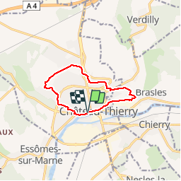
Château-Thierry Découverte N°1

VANDERPUTTENMi
User GUIDE

Length
9 km

Max alt
183 m

Uphill gradient
165 m
Km-Effort
11.2 km

Min alt
58 m

Downhill gradient
165 m
Boucle
Yes
Creation date :
2019-04-14 07:26:47.1
Updated on :
2019-04-17 14:20:00.107
2h28
Difficulty : Very easy

FREE GPS app for hiking
 SityTrail
IGN / Geographical institutes
SityTrail Plus
The world is yours!
About
Trail Walking of 9 km to be discovered at Hauts-de-France, Aisne, Château-Thierry. This trail is proposed by VANDERPUTTENMi.
Photos


Positioning
Country:
France
Region :
Hauts-de-France
Department/Province :
Aisne
Municipality :
Château-Thierry
Location:
Unknown
Start:(Dec)
Start:(UTM)
529073 ; 5432364 (31U) N.
Comments