


touch

ra2000
User
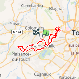

Length
31 km

Max alt
194 m

Uphill gradient
257 m
Km-Effort
34 km

Min alt
137 m

Downhill gradient
250 m
Boucle
No
Creation date :
2019-04-14 13:57:00.797
Updated on :
2019-04-14 16:02:18.883
2h03
Difficulty : Easy

FREE GPS app for hiking
 SityTrail
IGN / Geographical institutes
SityTrail Plus
The world is yours!
About
Trail Mountain bike of 31 km to be discovered at Occitania, Haute-Garonne, Colomiers. This trail is proposed by ra2000.
Positioning
Country:
France
Region :
Occitania
Department/Province :
Haute-Garonne
Municipality :
Colomiers
Location:
Unknown
Start:(Dec)
Start:(UTM)
366352 ; 4828000 (31T) N.
Comments