


orgon.camping

NADINE52
User
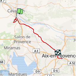

Length
66 km

Max alt
330 m

Uphill gradient
808 m
Km-Effort
77 km

Min alt
83 m

Downhill gradient
739 m
Boucle
No
Creation date :
2019-04-14 07:51:53.281
Updated on :
2019-04-14 17:03:51.569
8h22
Difficulty : Very easy

FREE GPS app for hiking
 SityTrail
IGN / Geographical institutes
SityTrail Plus
The world is yours!
About
Trail Walking of 66 km to be discovered at Provence-Alpes-Côte d'Azur, Bouches-du-Rhône, Orgon. This trail is proposed by NADINE52.
Positioning
Country:
France
Region :
Provence-Alpes-Côte d'Azur
Department/Province :
Bouches-du-Rhône
Municipality :
Orgon
Location:
Unknown
Start:(Dec)
Start:(UTM)
664313 ; 4849877 (31T) N.
Comments