


J1- Le puy- Privat St allier

ghislainem
User
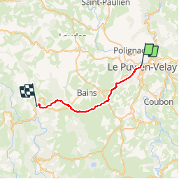

Length
24 km

Max alt
1215 m

Uphill gradient
652 m
Km-Effort
32 km

Min alt
641 m

Downhill gradient
449 m
Boucle
No
Creation date :
2019-04-15 06:06:22.801
Updated on :
2019-04-15 12:49:57.542
6h41
Difficulty : Difficult

FREE GPS app for hiking
 SityTrail
IGN / Geographical institutes
SityTrail Plus
The world is yours!
About
Trail Walking of 24 km to be discovered at Auvergne-Rhône-Alpes, Haute-Loire, Le Puy-en-Velay. This trail is proposed by ghislainem.
Positioning
Country:
France
Region :
Auvergne-Rhône-Alpes
Department/Province :
Haute-Loire
Municipality :
Le Puy-en-Velay
Location:
Unknown
Start:(Dec)
Start:(UTM)
569639 ; 4988405 (31T) N.
Comments