


corniche st clair ßete

jjduvar
User
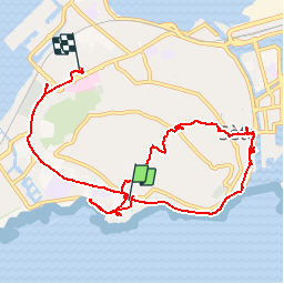

Length
11.9 km

Max alt
176 m

Uphill gradient
244 m
Km-Effort
15.1 km

Min alt
3 m

Downhill gradient
249 m
Boucle
No
Creation date :
2019-04-15 12:22:31.83
Updated on :
2019-04-15 15:56:27.214
2h35
Difficulty : Easy

FREE GPS app for hiking
 SityTrail
IGN / Geographical institutes
SityTrail Plus
The world is yours!
About
Trail Walking of 11.9 km to be discovered at Occitania, Hérault, Sète. This trail is proposed by jjduvar.
Positioning
Country:
France
Region :
Occitania
Department/Province :
Hérault
Municipality :
Sète
Location:
Unknown
Start:(Dec)
Start:(UTM)
554846 ; 4804810 (31T) N.
Comments