


damdam

bubu90
User
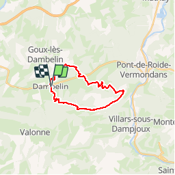

Length
19.3 km

Max alt
832 m

Uphill gradient
722 m
Km-Effort
29 km

Min alt
387 m

Downhill gradient
724 m
Boucle
Yes
Creation date :
2019-04-12 06:53:53.475
Updated on :
2019-04-18 10:57:37.802
5h14
Difficulty : Very easy

FREE GPS app for hiking
 SityTrail
IGN / Geographical institutes
SityTrail Plus
The world is yours!
About
Trail Walking of 19.3 km to be discovered at Bourgogne-Franche-Comté, Doubs, Dambelin. This trail is proposed by bubu90.
Positioning
Country:
France
Region :
Bourgogne-Franche-Comté
Department/Province :
Doubs
Municipality :
Dambelin
Location:
Unknown
Start:(Dec)
Start:(UTM)
324576 ; 5249419 (32T) N.
Comments