J3 Saugues- Sauvage

ghislainem
User
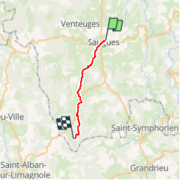

Length
21 km

Max alt
1331 m

Uphill gradient
626 m
Km-Effort
29 km

Min alt
928 m

Downhill gradient
296 m
Boucle
No
Creation date :
2019-04-17 06:15:03.241
Updated on :
2019-04-18 16:32:45.404
7h10
Difficulty : Very easy

FREE GPS app for hiking
 SityTrail
IGN / Geographical institutes
SityTrail Plus
The world is yours!
About
Trail Walking of 21 km to be discovered at Auvergne-Rhône-Alpes, Haute-Loire, Saugues. This trail is proposed by ghislainem.
Positioning
Country:
France
Region :
Auvergne-Rhône-Alpes
Department/Province :
Haute-Loire
Municipality :
Saugues
Location:
Unknown
Start:(Dec)
Start:(UTM)
543249 ; 4978723 (31T) N.
Comments