


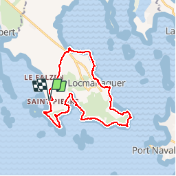
St Pierre Lopérec ,Locmariaquer via le GR 34

Axelloceane
User


3h40
Difficulty : Very easy

FREE GPS app for hiking
 SityTrail
IGN / Geographical institutes
SityTrail Plus
The world is yours!
About
Trail Walking of 14.9 km to be discovered at Brittany, Morbihan, Locmariaquer. This trail is proposed by Axelloceane.
Description
Départ de St Pierre Lopérec,puis suivre le balisage du GR 34.Passage par la pointe de er Hourel puis la pointe de Kerpenhir , vue sur l'entrée du golf du Morbihan .Ensuite traversée du village Locmariaquer en suivant toujours le GR 34 . Au lieu dit Le Palud tourner à gauche pour rejoindre St Pierre Lopérec par un chemin pédestre en passant par Kériaval et Kérhel.
Photos


Positioning
Comments