


touch.garonne

ra2000
User
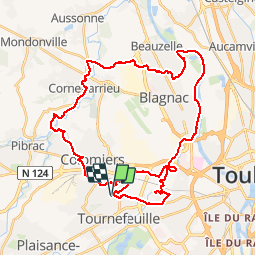

Length
47 km

Max alt
192 m

Uphill gradient
410 m
Km-Effort
52 km

Min alt
123 m

Downhill gradient
410 m
Boucle
Yes
Creation date :
2019-04-19 11:31:25.974
Updated on :
2019-04-19 14:56:37.36
3h22
Difficulty : Easy

FREE GPS app for hiking
 SityTrail
IGN / Geographical institutes
SityTrail Plus
The world is yours!
About
Trail Mountain bike of 47 km to be discovered at Occitania, Haute-Garonne, Colomiers. This trail is proposed by ra2000.
Description
Pas de difficultés si ce n'est la distance
Positioning
Country:
France
Region :
Occitania
Department/Province :
Haute-Garonne
Municipality :
Colomiers
Location:
Unknown
Start:(Dec)
Start:(UTM)
366150 ; 4828138 (31T) N.
Comments