


Durtol_Chanturgue

jagarnier
User GUIDE
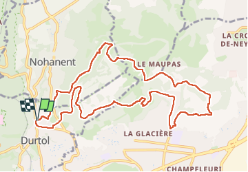

Length
12.5 km

Max alt
615 m

Uphill gradient
386 m
Km-Effort
17.6 km

Min alt
422 m

Downhill gradient
382 m
Boucle
Yes
Creation date :
2019-04-20 09:29:51.637
Updated on :
2024-08-22 15:50:06.264
3h45
Difficulty : Medium

FREE GPS app for hiking
 SityTrail
IGN / Geographical institutes
SityTrail Plus
The world is yours!
About
Trail Walking of 12.5 km to be discovered at Auvergne-Rhône-Alpes, Puy-de-Dôme, Durtol. This trail is proposed by jagarnier.
Photos

Positioning
Country:
France
Region :
Auvergne-Rhône-Alpes
Department/Province :
Puy-de-Dôme
Municipality :
Durtol
Location:
Unknown
Start:(Dec)
Start:(UTM)
504091 ; 5071674 (31T) N.
Comments