


randonnée cascade mullerthal

Alain Blanchy
User
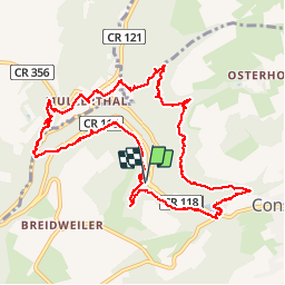

Length
11.4 km
Boucle
Yes
Creation date :
2019-04-21 11:19:25.401
Updated on :
2019-04-21 15:44:57.371
4h23
Difficulty : Difficult

FREE GPS app for hiking
 SityTrail
IGN / Geographical institutes
SityTrail Plus
The world is yours!
About
Trail Walking of 11.4 km to be discovered at Unknown, Canton Echternach, Consdorf. This trail is proposed by Alain Blanchy.
Description
joli trail
Positioning
Country:
Luxembourg
Region :
Unknown
Department/Province :
Canton Echternach
Municipality :
Consdorf
Location:
Unknown
Start:(Dec)
Start:(UTM)
306818 ; 5517864 (32U) N.
Comments