Trail Walking Châtel-Guyon - 
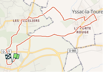
Chatel_Yssac_Tourette - Photo
 jagarnier
jagarnier

User GUIDE

© OpenStreetMap contributors
Length
Length
6.2 km
Max alt
Max alt
451 m
Uphill gradient
Uphill gradient
103 m
Km-Effort
Km-Effort  
7.6 km
Min alt
Min alt
376 m
Downhill gradient
Downhill gradient
102 m
Boucle
Boucle
Yes
Creation date :
2019-04-22 05:52:47.937
Updated on :
2023-12-05 16:46:15.765

(0 Reviews)

Walking
Walking
1h45
Difficulty : Easy

Scan this QR Code to open this trail in the SityTrail application

FREE GPS app for hiking

Logo SityTrail SityTrail

IGN / Geographical institutes

Download SityTrail from the App Store Download SityTrail from Google Play

Logo SityTrail SityTrail Plus

The world is yours!

Download SityTrail from the App Store Download SityTrail from Google Play Download SityTrail on Huawei AppGallery

About

Trail Walking of 6.2 km to be discovered at Auvergne-Rhône-Alpes, Puy-de-Dôme, Châtel-Guyon. This trail is proposed by jagarnier.

Description

Au départ de Chatel-Guyon cette randonnée traverse champs de blé et sous-bois pour gagner Yssac-la-Tourette. Vous découvrirez de nombreuses croix, des maisons de maître et un quartier vigneron.

Elevation profile

Photos

Positioning

Country:
France
Region :
Auvergne-Rhône-Alpes
Department/Province :
Puy-de-Dôme
Municipality :
Châtel-Guyon
Location:
Unknown
Start:(UTM)
505442 ; 5085707 (31T) N.


Close
My subscriptions