


boissay
User
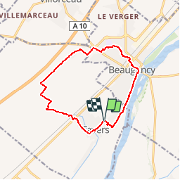

Length
12.2 km

Max alt
113 m

Uphill gradient
88 m
Km-Effort
13.4 km

Min alt
78 m

Downhill gradient
88 m
Boucle
Yes
Creation date :
2019-04-22 08:58:22.88
Updated on :
2019-04-22 08:58:22.88

FREE GPS app for hiking
 SityTrail
IGN / Geographical institutes
SityTrail Plus
The world is yours!
About
Trail of 12.2 km to be discovered at Centre-Loire Valley, Loiret, Tavers. This trail is proposed by boissay.
Positioning
Country:
France
Region :
Centre-Loire Valley
Department/Province :
Loiret
Municipality :
Tavers
Location:
Unknown
Start:(Dec)
Start:(UTM)
396415 ; 5290648 (31T) N.
Comments