


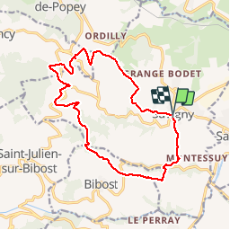
Savigny (rando Village 16 km-D. 535 m)

Thomasdanielle
User

Length
16 km

Max alt
526 m

Uphill gradient
534 m
Km-Effort
23 km

Min alt
273 m

Downhill gradient
521 m
Boucle
Yes
Creation date :
2019-04-22 07:17:20.0
Updated on :
2019-04-22 14:35:58.698
4h23
Difficulty : Difficult

FREE GPS app for hiking
 SityTrail
IGN / Geographical institutes
SityTrail Plus
The world is yours!
About
Trail Walking of 16 km to be discovered at Auvergne-Rhône-Alpes, Rhône, Savigny. This trail is proposed by Thomasdanielle.
Description
D/A : grand parking en arrivant à Savigny - (Proche de l'église)
Randonnée ne pas prévoir par grosse chaleur. Peu d'ombre
Positioning
Country:
France
Region :
Auvergne-Rhône-Alpes
Department/Province :
Rhône
Municipality :
Savigny
Location:
Unknown
Start:(Dec)
Start:(UTM)
622316 ; 5074732 (31T) N.
Comments