


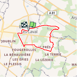
Boucle autour de Bonchamp

phimar_2612
User

Length
11.3 km

Max alt
95 m

Uphill gradient
100 m
Km-Effort
12.6 km

Min alt
68 m

Downhill gradient
100 m
Boucle
Yes
Creation date :
2019-04-22 12:49:44.154
Updated on :
2019-04-22 15:40:41.668
2h35
Difficulty : Easy

FREE GPS app for hiking
 SityTrail
IGN / Geographical institutes
SityTrail Plus
The world is yours!
About
Trail Walking of 11.3 km to be discovered at Pays de la Loire, Mayenne, Bonchamp-lès-Laval. This trail is proposed by phimar_2612.
Positioning
Country:
France
Region :
Pays de la Loire
Department/Province :
Mayenne
Municipality :
Bonchamp-lès-Laval
Location:
Unknown
Start:(Dec)
Start:(UTM)
671334 ; 5326949 (30U) N.
Comments