


Queyras - Ristola - La Monta

soca
User
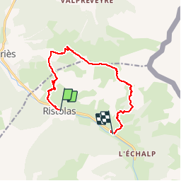

Length
11.7 km

Max alt
2583 m

Uphill gradient
992 m
Km-Effort
25 km

Min alt
1602 m

Downhill gradient
945 m
Boucle
No
Creation date :
2019-04-24 15:40:15.56
Updated on :
2019-04-24 15:59:25.799
4h54
Difficulty : Very difficult

FREE GPS app for hiking
 SityTrail
IGN / Geographical institutes
SityTrail Plus
The world is yours!
About
Trail Walking of 11.7 km to be discovered at Provence-Alpes-Côte d'Azur, Hautes-Alpes, Abriès-Ristolas. This trail is proposed by soca.
Positioning
Country:
France
Region :
Provence-Alpes-Côte d'Azur
Department/Province :
Hautes-Alpes
Municipality :
Abriès-Ristolas
Location:
Unknown
Start:(Dec)
Start:(UTM)
338301 ; 4959881 (32T) N.
Comments