


Refuge Questa - Refuge Cougourde, v2

pierre666
User
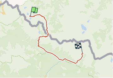

Length
26 km

Max alt
2607 m

Uphill gradient
1294 m
Km-Effort
44 km

Min alt
1510 m

Downhill gradient
1561 m
Boucle
No
Creation date :
2019-04-24 18:24:37.655
Updated on :
2019-04-24 18:26:03.314
8h51
Difficulty : Very difficult

FREE GPS app for hiking
 SityTrail
IGN / Geographical institutes
SityTrail Plus
The world is yours!
About
Trail Walking of 26 km to be discovered at Piemont, Cuneo, Valdieri. This trail is proposed by pierre666.
Description
Tracé à 19,8 km pour la section Questa - Cougourde.
Simplifié pour le passage au Boréon
Positioning
Country:
Italy
Region :
Piemont
Department/Province :
Cuneo
Municipality :
Valdieri
Location:
Unknown
Start:(Dec)
Start:(UTM)
357439 ; 4893728 (32T) N.
Comments