


La Bessiè (Pont de Tanus)/Villefranche de Rouergue

frank12
User
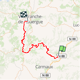

Length
96 km

Max alt
548 m

Uphill gradient
2878 m
Km-Effort
135 km

Min alt
152 m

Downhill gradient
3097 m
Boucle
No
Creation date :
2019-04-26 20:36:01.567
Updated on :
2019-04-26 20:38:48.788
4h00
Difficulty : Very easy

FREE GPS app for hiking
 SityTrail
IGN / Geographical institutes
SityTrail Plus
The world is yours!
About
Trail Moto cross of 96 km to be discovered at Occitania, Tarn, Tanus. This trail is proposed by frank12.
Positioning
Country:
France
Region :
Occitania
Department/Province :
Tarn
Municipality :
Tanus
Location:
Unknown
Start:(Dec)
Start:(UTM)
442683 ; 4885403 (31T) N.
Comments