


Monfroc

claude nier
User
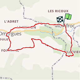

Length
9.7 km

Max alt
873 m

Uphill gradient
245 m
Km-Effort
13 km

Min alt
737 m

Downhill gradient
240 m
Boucle
Yes
Creation date :
2019-04-29 06:37:14.074
Updated on :
2019-04-29 12:08:02.395
2h57
Difficulty : Easy

FREE GPS app for hiking
 SityTrail
IGN / Geographical institutes
SityTrail Plus
The world is yours!
About
Trail Walking of 9.7 km to be discovered at Auvergne-Rhône-Alpes, Drôme, Montfroc. This trail is proposed by claude nier.
Description
marche douce
Andre Lisiane Martine Caroline et son mari
Jean pierre Michelle Jeannine Nicole et Moi
Positioning
Country:
France
Region :
Auvergne-Rhône-Alpes
Department/Province :
Drôme
Municipality :
Montfroc
Location:
Unknown
Start:(Dec)
Start:(UTM)
710896 ; 4894760 (31T) N.
Comments