


SityTrail - 1072977 - st-laurent-de-brevedent

doboul
User
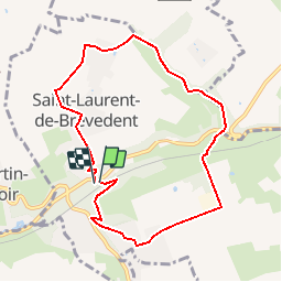

Length
7.9 km

Max alt
107 m

Uphill gradient
133 m
Km-Effort
9.7 km

Min alt
41 m

Downhill gradient
143 m
Boucle
Yes
Creation date :
2019-04-29 12:57:59.574
Updated on :
2019-04-29 12:57:59.574
--
Difficulty : Unknown

FREE GPS app for hiking
 SityTrail
IGN / Geographical institutes
SityTrail Plus
The world is yours!
About
Trail Walking of 7.9 km to be discovered at Normandy, Seine-Maritime, Saint-Laurent-de-Brèvedent. This trail is proposed by doboul.
Description
Le circuit jaune
Positioning
Country:
France
Region :
Normandy
Department/Province :
Seine-Maritime
Municipality :
Saint-Laurent-de-Brèvedent
Location:
Unknown
Start:(Dec)
Start:(UTM)
301576 ; 5490161 (31U) N.
Comments