


Priez ADR du 30/04/2019

VANDERPUTTENMi
User GUIDE
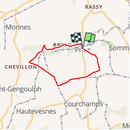

Length
9.3 km

Max alt
175 m

Uphill gradient
105 m
Km-Effort
10.7 km

Min alt
117 m

Downhill gradient
102 m
Boucle
Yes
Creation date :
2019-04-30 12:10:24.983
Updated on :
2019-05-01 10:21:09.275
2h23
Difficulty : Very easy

FREE GPS app for hiking
 SityTrail
IGN / Geographical institutes
SityTrail Plus
The world is yours!
About
Trail Walking of 9.3 km to be discovered at Hauts-de-France, Aisne, Priez. This trail is proposed by VANDERPUTTENMi.
Positioning
Country:
France
Region :
Hauts-de-France
Department/Province :
Aisne
Municipality :
Priez
Location:
Unknown
Start:(Dec)
Start:(UTM)
519243 ; 5442712 (31U) N.
Comments