


la Siagne depuis Escragnolles

aljac
User
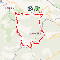

Length
17.5 km

Max alt
1042 m

Uphill gradient
749 m
Km-Effort
28 km

Min alt
484 m

Downhill gradient
748 m
Boucle
Yes
Creation date :
2019-04-30 07:58:59.703
Updated on :
2019-04-30 15:23:25.669
7h22
Difficulty : Difficult

FREE GPS app for hiking
 SityTrail
IGN / Geographical institutes
SityTrail Plus
The world is yours!
About
Trail Walking of 17.5 km to be discovered at Provence-Alpes-Côte d'Azur, Maritime Alps, Escragnolles. This trail is proposed by aljac.
Positioning
Country:
France
Region :
Provence-Alpes-Côte d'Azur
Department/Province :
Maritime Alps
Municipality :
Escragnolles
Location:
Unknown
Start:(Dec)
Start:(UTM)
322234 ; 4844216 (32T) N.
Comments