Trail Walking Aubagne - Le Garlaban et le Pic du Taoumé - Photo

Le Garlaban et le Pic du Taoumé

 jpb83
jpb83

User

© OpenStreetMap contributors
Length
Length
12.8 km
Max alt
Max alt
689 m
Uphill gradient
Uphill gradient
641 m
Km-Effort
Km-Effort  
21 km
Min alt
Min alt
260 m
Downhill gradient
Downhill gradient
641 m
Boucle
Boucle
Yes
Creation date :
2019-05-01 05:08:42.206
Updated on :
2019-05-01 05:12:19.597

(0 Reviews)

Walking
Walking
4h21
Difficulty : Medium
Trail
Trail
1h38
Difficulty : Difficult

Scan this QR Code to open this trail in the SityTrail application

FREE GPS app for hiking

Logo SityTrail SityTrail

IGN / Geographical institutes

Download SityTrail from the App Store Download SityTrail from Google Play

Logo SityTrail SityTrail Plus

The world is yours!

Download SityTrail from the App Store Download SityTrail from Google Play Download SityTrail on Huawei AppGallery

About

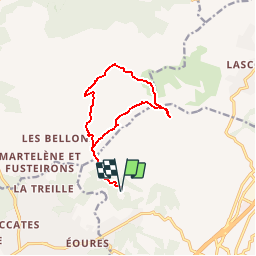
Trail Walking of 12.8 km to be discovered at Provence-Alpes-Côte d'Azur, Bouches-du-Rhône, Aubagne. This trail is proposed by jpb83.

Description

Cette Boucle va sur les traces de Marcel Pagnol. Elle passe par la Baume du Plantier (Grotte de Manon) puis rejoint le mythique Garlaban. Le retour se fait par le Pic du Taoumé et la Grotte du Grosibou pour finir par le Vallon de Passe-Temps.

Elevation profile

Points of interest

Positioning

Country:
France
Region :
Provence-Alpes-Côte d'Azur
Department/Province :
Bouches-du-Rhône
Municipality :
Aubagne
Location:
Unknown
Start:(UTM)
705706 ; 4798879 (31T) N.


Close
My subscriptions