


CLD-MM- le 30/04/2019 (Chateldon-Ris)

JackPG
User
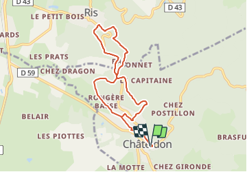

Length
8.1 km

Max alt
414 m

Uphill gradient
201 m
Km-Effort
10.8 km

Min alt
301 m

Downhill gradient
201 m
Boucle
Yes
Creation date :
2019-05-01 08:06:56.771
Updated on :
2021-09-10 07:35:55.398
2h18
Difficulty : Medium

FREE GPS app for hiking
 SityTrail
IGN / Geographical institutes
SityTrail Plus
The world is yours!
About
Trail Walking of 8.1 km to be discovered at Auvergne-Rhône-Alpes, Puy-de-Dôme, Châteldon. This trail is proposed by JackPG.
Photos
 - Photo 1")
 - Photo 2")
Positioning
Country:
France
Region :
Auvergne-Rhône-Alpes
Department/Province :
Puy-de-Dôme
Municipality :
Châteldon
Location:
Unknown
Start:(Dec)
Start:(UTM)
540399 ; 5091562 (31T) N.
Comments