


Sortie à vélo l'après-midi(VAE)

benoit48
User
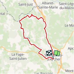

Length
28 km

Max alt
1150 m

Uphill gradient
537 m
Km-Effort
35 km

Min alt
979 m

Downhill gradient
538 m
Boucle
Yes
Creation date :
2019-05-01 10:10:01.086
Updated on :
2019-05-01 10:11:33.587
2h00
Difficulty : Easy

FREE GPS app for hiking
 SityTrail
IGN / Geographical institutes
SityTrail Plus
The world is yours!
About
Trail Mountain bike of 28 km to be discovered at Occitania, Lozère, Saint-Chély-d'Apcher. This trail is proposed by benoit48.
Positioning
Country:
France
Region :
Occitania
Department/Province :
Lozère
Municipality :
Saint-Chély-d'Apcher
Location:
Unknown
Start:(Dec)
Start:(UTM)
521694 ; 4960474 (31T) N.
Comments