


Sortie club a VTT

benoit48
User
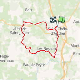

Length
27 km

Max alt
1216 m

Uphill gradient
496 m
Km-Effort
34 km

Min alt
982 m

Downhill gradient
495 m
Boucle
Yes
Creation date :
2019-05-01 10:12:07.694
Updated on :
2019-05-01 10:13:15.511
2h00
Difficulty : Easy

FREE GPS app for hiking
 SityTrail
IGN / Geographical institutes
SityTrail Plus
The world is yours!
About
Trail Mountain bike of 27 km to be discovered at Occitania, Lozère, Saint-Chély-d'Apcher. This trail is proposed by benoit48.
Positioning
Country:
France
Region :
Occitania
Department/Province :
Lozère
Municipality :
Saint-Chély-d'Apcher
Location:
Unknown
Start:(Dec)
Start:(UTM)
521729 ; 4961615 (31T) N.
Comments