


Chéserex - Barillet

gut72ch
User
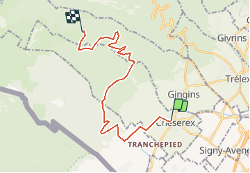

Length
13 km

Max alt
1489 m

Uphill gradient
1033 m
Km-Effort
24 km

Min alt
532 m

Downhill gradient
80 m
Boucle
No
Creation date :
2014-12-10 00:00:00.0
Updated on :
2014-12-10 00:00:00.0
1h40
Difficulty : Difficult

FREE GPS app for hiking
 SityTrail
IGN / Geographical institutes
SityTrail Plus
The world is yours!
About
Trail Running of 13 km to be discovered at Vaud, District de Nyon, Chéserex. This trail is proposed by gut72ch.


Positioning
Country:
Switzerland
Region :
Vaud
Department/Province :
District de Nyon
Municipality :
Chéserex
Location:
Unknown
Start:(Dec)
Start:(UTM)
282584 ; 5142442 (32T) N.
Comments