


Abbatiale d'Ebersmunster

Claudele
User
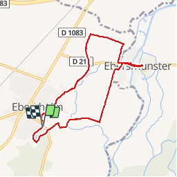

Length
7.5 km

Max alt
169 m

Uphill gradient
38 m
Km-Effort
8 km

Min alt
156 m

Downhill gradient
39 m
Boucle
Yes
Creation date :
2019-05-02 07:32:39.738
Updated on :
2019-05-02 10:16:10.64
2h26
Difficulty : Very easy

FREE GPS app for hiking
 SityTrail
IGN / Geographical institutes
SityTrail Plus
The world is yours!
About
Trail Walking of 7.5 km to be discovered at Grand Est, Bas-Rhin, Ebersheim. This trail is proposed by Claudele.
Photos


Positioning
Country:
France
Region :
Grand Est
Department/Province :
Bas-Rhin
Municipality :
Ebersheim
Location:
Unknown
Start:(Dec)
Start:(UTM)
388917 ; 5350828 (32U) N.
Comments