


Boscodon

Renefrt
User
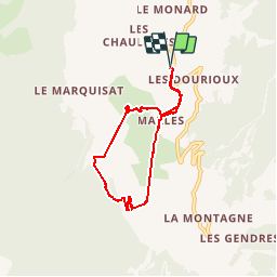

Length
6.2 km

Max alt
1348 m

Uphill gradient
318 m
Km-Effort
10.4 km

Min alt
1127 m

Downhill gradient
315 m
Boucle
Yes
Creation date :
2019-05-02 07:18:26.791
Updated on :
2019-05-02 11:01:22.282
3h22
Difficulty : Medium

FREE GPS app for hiking
 SityTrail
IGN / Geographical institutes
SityTrail Plus
The world is yours!
About
Trail Walking of 6.2 km to be discovered at Provence-Alpes-Côte d'Azur, Hautes-Alpes, Crots. This trail is proposed by Renefrt.
Photos


Positioning
Country:
France
Region :
Provence-Alpes-Côte d'Azur
Department/Province :
Hautes-Alpes
Municipality :
Crots
Location:
Unknown
Start:(Dec)
Start:(UTM)
298751 ; 4931721 (32T) N.
Comments
Attention dans les guides il est fait état d'un passage dans la rivière, il faut la traverser avec de l'eau jusqu'au genoux, c'est une randonnée bien sympathique, et il faut visiter l'abbaye.