


Merlieux-et-Fouquerolles

VANDERPUTTENMi
User GUIDE
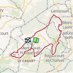

Length
18.1 km

Max alt
192 m

Uphill gradient
353 m
Km-Effort
23 km

Min alt
83 m

Downhill gradient
353 m
Boucle
Yes
Creation date :
2019-05-02 07:41:00.53
Updated on :
2019-05-04 20:29:26.538
5h34
Difficulty : Very easy

FREE GPS app for hiking
 SityTrail
IGN / Geographical institutes
SityTrail Plus
The world is yours!
About
Trail Walking of 18.1 km to be discovered at Hauts-de-France, Aisne, Merlieux-et-Fouquerolles. This trail is proposed by VANDERPUTTENMi.
Positioning
Country:
France
Region :
Hauts-de-France
Department/Province :
Aisne
Municipality :
Merlieux-et-Fouquerolles
Location:
Unknown
Start:(Dec)
Start:(UTM)
536669 ; 5485471 (31U) N.
Comments