


Chapelle Ste Christine - Valcros - Grotte de Trubis

soca
User
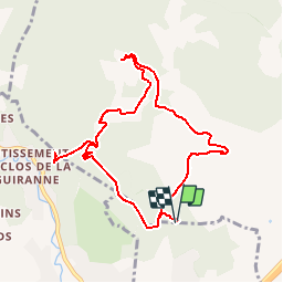

Length
10.4 km

Max alt
335 m

Uphill gradient
409 m
Km-Effort
15.8 km

Min alt
137 m

Downhill gradient
406 m
Boucle
Yes
Creation date :
2019-05-02 16:14:20.976
Updated on :
2019-05-02 16:31:39.46
3h17
Difficulty : Difficult

FREE GPS app for hiking
 SityTrail
IGN / Geographical institutes
SityTrail Plus
The world is yours!
About
Trail Walking of 10.4 km to be discovered at Provence-Alpes-Côte d'Azur, Var, Cuers. This trail is proposed by soca.
Positioning
Country:
France
Region :
Provence-Alpes-Côte d'Azur
Department/Province :
Var
Municipality :
Cuers
Location:
Unknown
Start:(Dec)
Start:(UTM)
259935 ; 4789208 (32T) N.
Comments