


Yvetot St Wandrille

ves
User
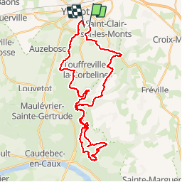

Length
36 km

Max alt
141 m

Uphill gradient
783 m
Km-Effort
46 km

Min alt
8 m

Downhill gradient
782 m
Boucle
No
Creation date :
2019-05-03 08:08:32.0
Updated on :
2019-05-03 10:20:05.875
2h12
Difficulty : Unknown

FREE GPS app for hiking
 SityTrail
IGN / Geographical institutes
SityTrail Plus
The world is yours!
About
Trail Mountain bike of 36 km to be discovered at Normandy, Seine-Maritime, Yvetot. This trail is proposed by ves.
Description
Circuit sportif
Positioning
Country:
France
Region :
Normandy
Department/Province :
Seine-Maritime
Municipality :
Yvetot
Location:
Unknown
Start:(Dec)
Start:(UTM)
338743 ; 5497477 (31U) N.
Comments